Showing posts with label scenic areas. Show all posts

Friday, April 28, 2023

Geiger Lookout Wayside Park- A Nice Stop with Great Views on the way to and from Virginia City

Geiger Lookout is a favorite spot for sunset lovers and curious travelers making their way to and from Virginia City. You’ll find this gem just a bit up the winding road from Reno, with a turnout offering about 11 parking spaces.

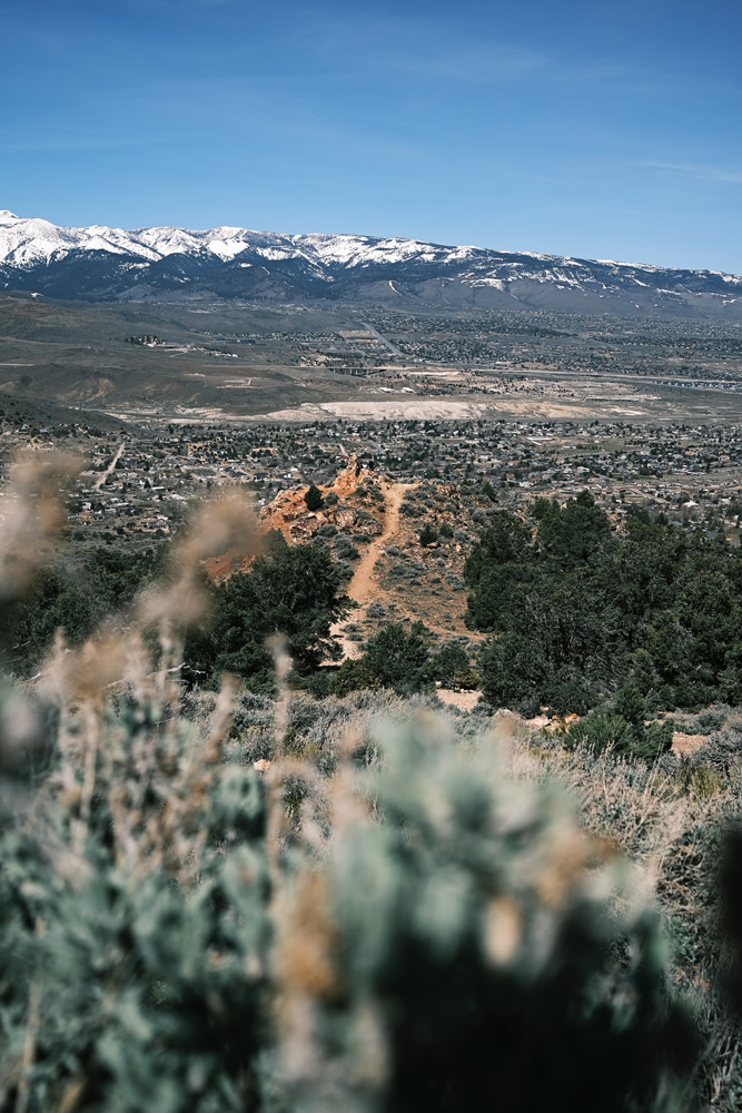
One of the coolest things about Reno is how diverse it is, with rivers, farmland, forests, and the Old West vibe all within a short drive of each other. At Geiger Lookout, you’ll be treated to rock-lined paths, muted nature colors, and vibrant red mineral mountains, creating a truly unique experience.

With multiple lookout points, you’ll soak in sweeping views of Mt. Rose, the Sierra Mountains, and Downtown Reno. Sitting at about 1,000 feet above the Truckee Meadows, you’ll feel on top of the world, surrounded by stunning scenery.

The park also features the remnants of 1938 barbecues, wells, and even a “love seat,” bringing visitors back in time and sparking curiosity about its history.

Just a quick 15-minute drive up a scenic, winding road will lead you to Virginia City, a charming town steeped in rich mining history and that classic “old west” feel.

Throughout the year, Virginia City comes alive with annual events, parades, and tours, making it a hotspot for tourists. With ghost tours, saloons, restaurants, and unique boutiques, there’s no shortage of exciting experiences waiting for you in the "Wild Wild West."

Together, Geiger Grade Lookout and Virginia City offer the perfect day trip: a mix of breathtaking natural views, historical intrigue, and classic Old West charm. Whether you’re soaking in the sunset from the lookout or wandering the streets of Virginia City, you’ll leave with a deeper appreciation for the beauty and history that surrounds Reno.

Fun Fact: Geiger Grade was once a crucial route for miners traveling between Reno and Virginia City during the Comstock Lode boom, and Virginia City itself still preserves many buildings from that era.  Some are over 150 years old.

Notes 
-A plaque at the stone stairs commemorates Dr. Davison M. Geiger, a local physician who helped finance the original Geiger Grade Road. The stairs lead to the lookout and a cozy “love seat” where you can relax and take in the views.
-The park covers approximately 2 acres.
-Partial shade is available under the trees.
-There are no functional restrooms on site, so plan accordingly.
-It can get windy, so check the weather and dress appropriately before your visit.
-Dr. Geiger had strong ties to the Virginia City / Comstock Lode area, where he was active in the local church (source).

Categorized under "Parks and Playgrounds" & "Scenic Overlooks"

*Information subject to change.  All opinions are my own.

Photography 
©Katherine Fung
All Rights Reserved

Monday, November 9, 2020

Take a Short and Scenic Hike to a Stunning Waterfall on Mt. Rose Summit Trail


(about 30 mins. from Reno)


When I think about why I love living in Reno, Mt. Rose Summit Trail is definitely near the top of the list. This 11.8 mile loop trail offers stunning views and fun for every skill level.

With little effort and a fairly flat path (aside from a short stretch at the beginning), you’ll wind through the woods and reach beautiful Galena Falls in just about 2.5 miles. The view of the meadow in the area is a bonus. Because it takes only a small amount of effort to get to this gorgeous waterfall, this part of the hike can get busy.

I’ve only made it to the falls, but from what I’ve read in other reviews, the hike becomes more challenging from there on out, with the last 1.5 miles being the toughest climb. Still, many find the hike rewarding, thanks to the breathtaking views of the Lake Tahoe Basin, Washoe Valley, and Reno.

Trail Overview
Best used: May through October when the snow melts and before winter hits 
Distance: 11.8 mile loop  
Duration: 4.5 to 6 hours round trip  
Elevation: 10,778 ft. Be mindful of altitude sickness, especially above 8,000 feet. 


Trail Conditions
Shade: Lots of shade is found at the beginning throughout the journey to the waterfall
Terrain: The trail starts fairly flat (except for the beginning), but the last 1.5 miles are suppose to be more challenging.  
Restrooms:  Located at trailhead parking lot. Open seasonally.

Recommendations
Wind Protection: The summit is said to always be windy.  Bring a windbreaker no matter the season.  
Sun Protection: Don’t forget sunblock. The higher you are, the more intense the sun is. 
Hydration & Snacks: Bring plenty of water and snacks.  There are picnic opportunities throughout the hike.  
Walking Aids: Many hikers find walking poles helpful for the rocky sections and the ascent.

Seasonal Tips
Crowds: To beat the crowds, go on a weekday or early on weekends during summer. Parking lots fill up fast.  
Winter Activities: In winter, people love to sled and play in the snow near the parking lot. 
Wildlife Viewing: In mid to late August, you might catch the amazing Monarch Butterfly migration.  
Fall Beauty: The trail is beautiful in the fall and vibrant in spring and summer, with lots of wildlife and wildflowers.

Nearby 
Tahoe Meadows: If you’re looking for a lovely flat hike nearby, check out the Tahoe Meadows Interpretive Loop trail just down the road to the left (you can't miss the parking lot). The Tahoe Meadows South Trailhead is just a minute away from the lot on the main road.  During summer, they open the gates that lead to a parking lot closer to the trailhead. 

Winter Hiking  
Snowshoeing and cross country skiing are popular activities here in the winter.  Proper gear is essential. Be sure to check the weather in advance and dress appropriately. Serious winter hikers like to use an app to help keep them on track, especially when you'll have access to the trails even without reception.


If you want to see an amazing video that does this trail justice, check out this video made by Supai Adventures.  You can even run into butterflies!!!


Right Next to Mt. Rose Summit Trailhead Parking Lot

Categorized under "Family Friendly Hikes

Monday, June 15, 2020

Brown's Creek Loop Trail- A Hike with some Breathtaking Views


3584-3694 Joy Lake Road
Reno, NV 89511
AllTrails Map
***Trail currently closed due to Davis Fire***

Brown's Creek Snapshot
If you’re looking for a beautiful outdoor escape near Reno, Brown's Creek Trail is the place to be. This scenic hike features stunning views, vibrant wildflowers, and the soothing sounds of the creek. It’s perfect for families and anyone who loves nature. With its diverse terrain and breathtaking surroundings, it’s a rewarding adventure that showcases the beauty of our area and creates unforgettable memories in the great outdoors.

Moderate
4.8 mi. loop
2hr 25mins. estimated time


I'm always on the lookout for hikes near Reno that are beautiful, and since my kids were getting more skilled and interested in hitting the trails, I decided to push our limits with a longer hike. Usually, we stick to 2-mile trails, so tackling 4.8 miles felt like a bit of a stretch with a 5, 6, and 1-year-old in tow. But if there's one thing I've learned in life, it's that we humans are capable of so much more than we think.

The first part of the trail, before you reach the loop, weaves through the woods with a gentle uphill slope (over about a mile). You’ll hit the first fork, which is definitely worth a stop—the Vista (just a couple of minutes away). Here, you’ll find a bench, breathtaking views, and an educational sign about a former family attraction called Sundown Town. The second fork marks the beginning of the loop (not far from the Vista). If you take the left side, you’ll tackle the steeper part of the loop; opt for the right if you want a bit more of a challenge.

There are three small bridges that cross the creek. We took a break at the first bridge so the kids could dip their toes in and have some fun. It was so nice, with plenty of trees providing shade. After crossing the second bridge, you’ll arrive at the third fork. We took a wrong turn at this fork, heading straight into the “National Forest” (the loop sign was a bit farther up and faced the wrong way) and ended up hiking an extra 1.5 miles.  Once we realized we were off track, we retraced our steps and found the sign. Instead of going straight, make sure to head upward and to the right to stay on course. After the third fork, we crossed the final bridge and made our way back to the parking lot.

In total, we covered about 8.5 miles, and it was such an empowering and rewarding journey. My family and I met plenty of friendly dogs, admired stunning wildflowers, and encountered many kind people along the way.

We set off on what turned out to be one of the most beautiful, challenging, and rewarding hikes. The trail was filled with stunning views and varied terrains. Wandering through the Galena forest and crossing tranquil Brown's Creek was incredibly refreshing. I can't recommend this hike enough.

Notes
-Ever since getting lost, I make sure to use AllTrails to track my hikes.  
-Dogs, horses, and cyclists are allowed on the trail.  
-Enter the Galena Estates to find the trail entrance parking lot on the left side of Joy Lake Road.  
-The trail entrance is across the street-
-Bring plenty of water
-If hiking with kids, pack lots of snacks. I also brought a portable toilet for the kids, along with sunscreen & hand sanitizer.  
-There’s plenty of shade throughout the hike, but there are also exposed areas.  
-Have your phone handy for emergencies.  
-Alcohol pads and band-aids for unexpected scrapes
-Good footwear highly recommended  
-hiking poles may come in handy for those looking for more stability
-lots of vegetation, lizards, and insects to look at.  

 Pick right side for more of a challenge to go up steep left side at end of loop. Left side to go down steeper side.

*Information subject to change.  All opinions are my own.

Photography 
© Katherine Fung,
All rights reserved.

Friday, March 6, 2020

Take A Short and Scenic Stroll by the Truckee River at the Oxbow Nature Study Center


Hours: 
Open Year-Round from 8AM to 4pm
(The gates close, so make sure to head out before they lock up.)

Website
Yelp

Oxbow Nature Study Area is a 22-acre conservation spot in Reno, perfect for families or anyone looking to escape into nature without actually leaving the city.

Highlights
-Beautiful scenery
-Tranquility
-Wildlife
-Picnic-worthy spots
-Soothing sounds of nature
-Fun 0.8-mile loop trail
-Partial shade from trees
-Right next to the Truckee River
-Visitor’s center

When I first visited this park years ago, I immediately fell in love with the whole vibe. The towering trees, the winding ramps, the interpretive signs that make you pause and learn something new, the visitor center, wildlife, picnic tables, and the peaceful sounds of nature, all nestled right by the Truckee River. 

Growing up, some of my best memories were with my grandma, walking in parks near my house. We'd sit around, relax, snack, and just enjoy being together. Those were the moments of peace and connection that I knew I wanted to share with my own kids.

Parks like Oxbow have become my favorite for that reason.  They’re the perfect backdrop for building memories, just like the ones I had with my grandparents.

The Oxbow Nature Study Area is truly the best place for a quick escape from the city. It’s somewhere you can just relax, take a breath, and really soak in Reno’s natural beauty.

NOTES
-No dogs allowed
-Restrooms and a water fountain are available during park hours
-Benches are scattered around the visitor's center & along the trail, with a couple right by the river. 
-To get to the deck by the river, take the path all the way to the left, opposite of the education exhibit next to the observation deck
-The trail has lots of shady spots, which is a huge plus, especially during Reno’s hot summers 
-I had no issues navigating the trail with my stroller, but after rain, it can get a bit muddy. Toward the end of the trail, there’s a log bridge that isn’t stroller or wheelchair-friendly, so it’s best to turn back before that


Pictures taken during winter, 2020